
| China Travel Briefing | Destination Guide | Attractions | China Tours | Transportation | Cuisine | Shopping | Entertainment |
| Incentives and Meetings | Festivals and Themes | Accommodations | FAQ | Guestbook | Links | Contact US | Home |
Geography
The Inner Mongolia Autonomous Region extends across the north frontier of China, covering 1.183 million square km, adjoining Heilongjiang, Jilin, and Liaoning provinces in the east, and Hebei, Shanxi and Shaanxi provinces in the south, Ningxia and Gansu to its west and bordering on the Republic of Mongolia and the Federation of Russia to the north.
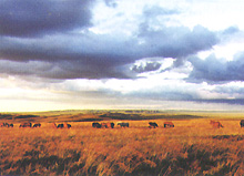
The bordering line extends 4221 km long. The topography of Inner Mongolia is mainly composed of plateaus, extending 3000 km from northeast to southwest, and most of them are more than 1000 meters above sea level. In the region, the area of grassland is 880,000 square km, or accounting for 21.7 percent of the nation's total, the leading of China's five largest grasslands. From east to west, are scattered grassy marshland, typical grassland, wilderness grassland, grassy wilderness, and desert as well as hilly grassy marshlands, low wet and grassy marshland, and marshy grassland, distributed randomly anywhere.
In the east, there are boundless primitive forests in the Greater Xinggan (or Hinggan) Mountain Range, and in the west, there is a large area of desert centering on the Ordos Plateau. The extended areas from the plateaus are plains mainly formed by the reaches of the Yellow River and the Liaohe River, known as the Hetao area and Liao-Nen area.
|
| Adventure to the Wild West of China |
|
|
This website is developed and managed by www.ChinaPlanner.com, a China travel service provider and a China tour operator. 566 7th Ave, Suite 506, New York, NY 10018, U.S.A. Copyright 1995 - 2003 All Rights Reserved. For More Information, Please Contact us at: Phones: (212) 382-3725 / Fax: (212) 382-3701 or by e-mail |