| Located in the Changbai Mountains in southwestern
Jilin Province, the prefecture borders Russia in the east and is separated
from the Democratic People's Republic of Korea by the Tumen River in
the south.
 The
Yanbian Korean Autonomous Prefecture has an area of 42,000 square kilometers
and a population of 1.98 million, 880,000 or 41.8 percent are Koreans.
There are also 19 other ethnic tribes such as the Han, Manchu, Hui,
Mongolian, Xibe, and Miao. Yanji City is the prefecture's capital. The
Yanbian Korean Autonomous Prefecture has an area of 42,000 square kilometers
and a population of 1.98 million, 880,000 or 41.8 percent are Koreans.
There are also 19 other ethnic tribes such as the Han, Manchu, Hui,
Mongolian, Xibe, and Miao. Yanji City is the prefecture's capital.
The prefecture, a land of songs and dances known in and outside of
China, has green mountains and clear waters. Buried underground everywhere
are precious mineral deposits. The Koreans are an ethnic group good
at singing and dancing. They are enthusiastic, bold, and unconstrained.
Xianjingtai National Scenic Area
Situated in the southeastern part of the Yanbian Korean Autonomous Prefecture,
100 kilometers from Yanji City and 130 kilometers from Helong City,
the scenic area stretches for 499 square kilometers, and the main peak
stands 920 meters in elevation. The mountain peaks present a unique
topographic feature be cause of the crevices in the granite rocks and
spherical weathering.
There are more than 300 man-made landscapes, including the site once
visited by Daqinmao or the third King Wen ofBohaiState during the Tang
Dynasty, ruins of the Qixing Temple, Nanping Port on the upper reaches
of the Tumen River, and scenes on the other side of the border in the
Democratic People's Republic of Korea such as Musan, a steel production
center; Chongsan Port; and the historical site of the revolutionary
war at Leingngdao. The scenic area is of great value for scientific
research and tourism development.
 The
Scenery of Fangchuan The
Scenery of Fangchuan
Seventy kilometers south of Hunchun City is Fangchuan, a village at
the foot of Zhanggu Peak in Jingxin Township. Several kilometers further
ahead is the marker erected on the border between China and Russia in
1886 under the supervision of Wu Dacheng, the imperial envoy of the
Qing Dynasty, and the representative of tsarist Russia. The village
is merely 15 kilometers from the Tumen River. From the lookout tower
on top of a hill in the vicinity, one can have a blurred vision of the
mist-shrouded Nippon Hai extending to the horizon in the distance and
the scenes along China's border with the D.P.R.K. and Russia. On the
left is Russia's Podgornaya and on the right is Tumangng of the D.P.R.K.
The Scenery of Hunchun
Bording Russia and the D.P.R.K., on the lower reaches of the Tumen River,
the city of Hunchun faces the river and the sea and backs on mountains.
It has rich natural resources. The Annals of Hunchun records,
"Hunchun has mountains at its back and the sea in front. The rolling
mountains, offsets of the northern section of the Changbai Mountains,
present an enchanting landscape. When spring changes into summer every
year, wild flowers are in full blossom and birds twitters in the trees.
Scenic spots are to be found everywhere, of which eight have long been
famous." These eight scenic attractions include the Roar of Waves
at an Ancient Ferry, the Mirror-Smooth Water at Longquan, the Spring
Bright Sky over the Willow-Grown River Banks, the Lotus Pond with Nine
Turns, Deer in the Wood Covered with Frost, and Rolling Hills under
Snow. These natural scenes have attracted numerous tourists.
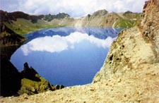
 Tianchi
Lake in the Changbai Mountains Tianchi
Lake in the Changbai Mountains
Lying in the crater of a volcanic cone on the summit of the main peak
of the Changbai Mountains, Tianchi Lake was formed with water accumulated
through the years. It is the largest crater lake in China with a concentration
of scenic spots in the Changbai Mountains. The oval-shaped lake resembles
a lotus flower floating on the water surface and a jasper inlaid among
the 16 peaks of the Changbai Mountains. The lake's water surface is
2,189 meters above sea level, the highest of its kind in China. As the
border lake between China and the D.P.R.K., Tianchi Lake stretches for
3.37 kilometers from east to west and 4.4 kilometers from south to north,
with an area of 10 square kilometers. The lake water is as deep as 373
meters at the deepest spot. Weather is changeable in the lake area,
and the lake water is often found to be enshrouded in clouds and mist.
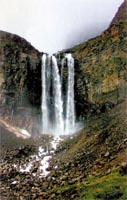
Scenes of Waterfalls
Known as the "source of rivers and lakes," the Changbai Mountains
have abundant water sources. The mountains are high in elevation and
have steep slopes and many gorges, giving to the rise of numerous waterfalls.
The Changbai Waterfall, 1,250 meters from Tianchi Lake, is an outlet
of the lake water flowing between Longmen and Tianhuo peaks to join
the Chengcha River. The waterfall has a flow of 1.25-5 cubic meters/per
second. It cascades down over a 68meter-high cliff like a white jade
belt hanging in the sky, bringing about a thunderous roar and foam that
splashes several meters high in the air. There are also the Tizi River,
Yuehua, Dongtian, Yinliu and Binghu Valley waterfalls.
 Hot
and Cold Springs Hot
and Cold Springs
China is a country with the largest number of hot springs in the world,
and the Changbai Mountains have a concentrated distribution of hot springs
in China. The wellknown Changbai Hot spring is to the north of Tianchi
Lake. Other hot springs are scattered over an area of more than 1,000
square meters, 900 meters from the Changbai Hot Spring. The Erdaobai
River flows through clusters of hot springs. On the right side of the
river are several dozen spring mouths, including seven large ones, and
another five on the left side. They are high-temperature springs whose
temperatures differ, ranging from 60 ? to 80 ?. The spring water gushes
out of the ground like that spitted out of dragons' mouths. Eggs would
be well cooked in 15 minutes in the hot water. The spring water sends
off a gas of hydrogen sulfide and contains such microelements as calcium
and magnesium. It is referred to as a magic water."
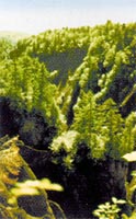
The Great Gorge in the Changbai Mountains
The majestic Changbai Mountains feature endless mountain peaks and winding
valleys. The Great Gorge in the mountain range, a natural spectacle
discovered in recent years, can rival the Great Canyon in the United
States. It is more than 70 kilometers long, 1 to 2 meters wide, and
over 100 meters deep. Rising in a stretch of virgin forest, the Great
Gorge cuts through the southwestern slope of the Changbai Mountains
to run rapidly downhill. There are odd-shaped peaks, bizarre rocks,
secluded valleys, clear waters, ancient trees, and rare grass on both
sides. A section of more than 10 kilometers of the primitive Great Gorge
presents the most magnificent sight. |